Markup Tools & Styles
TrafficCAD's drafting model is Bluebeam's, on a live map: a map toolbar of drawing tools, a style bar under the top toolbar, a right Properties panel for the selected object, and tool defaults you can set once and reuse. This page covers the general markup tools; the parametric objects (roads, fences, TTC plans…) each have their own page.
The map toolbar
The drawing toolbar sits at the top-left of the map and never collapses. In order:
| Tool | What it does |
|---|---|
| Select / move | Select, move, and edit control points. Shift-click a control point removes it; Shift-click an edge adds one. Esc always returns here. |
| Dimension | Two snap points, then drag the offset. See Dimensions. |
| Line / Polyline | Straight line (two clicks) / multi-vertex line (double-click to finish). |
| Rectangle / Polygon | Rectangle markup / work-area polygon. |
| Circle / Freehand / Text | Vector sketches — a circle, a drawn stroke, or a text marker; they land on the Sketches layer in the Layers panel. |
| Zone (polygon / rect / circle) | Event zones with automatic m² labels — Event Planning. |
| Route | Pedestrian / vehicle / emergency route with automatic length. |
| Walking path | Parametric path — width, surface, edges. |
| Parking lot | Draw the boundary; stalls auto-fit inside. |
| Fence | Parametric fence system — Fencing. |
| Channelizing devices | Device line — hover the button for the nested single-device tool (one cone/drum/panel/barricade). Channelizing Devices. |
| Road / Roundabout | Parametric roadway — Roads & Vectorize. |
| Marking line | MUTCD pavement markings — hover the button for the nested Marking area, Crosswalk, and Split marking tools. Pavement Markings. |
| Mask | Paint over the basemap to hide what's in the way. |
One-shot vs. pinned. A single click arms a tool for one markup, then returns to Select — the Bluebeam convention. Double-click a tool to pin it (an amber dot marks a pinned tool) and it stays active until you press Esc or pick another tool.
Nested tools. A small corner triangle marks a button with related tools nested inside — hover it and they appear beside the toolbar. The tool you pick becomes the visible button (the last-used tool stays on top, like CAD flyouts), with the rest waiting under the hover.
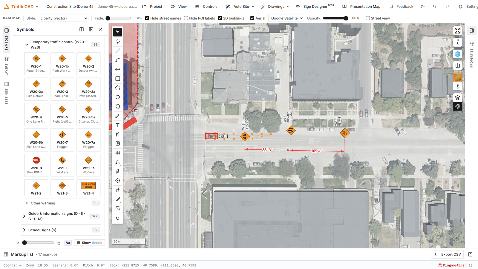
A rectangle markup over the street: pick the tool, click two corners, and the markup commits with grips ready for editing.
Tools show and hide with the workspace mode: roads, roundabouts, markings, and crosswalks are traffic-mode tools; zones and routes are event-mode tools; everything else is in both.
Committing and canceling
- Multi-vertex tools (polygon, polyline, zone, route, road, walkpath, fence, channelizer, marking line/area, mask, parking lot): click vertices, then double-click or Enter to commit.
- Esc cancels — in stages. It first cancels the active drag or pending geometry, then falls back to Select. It also closes the context menu and steps focus out of a label.
- Right-click never draws — it opens the context menu.
The style bar
The style bar appears under the top toolbar whenever a styleable tool is armed (Line, Polyline, Rectangle, Polygon, Dimension) or styleable markups are selected. Its context chip tells you what you're editing — a selection ("3 markups") or a tool's defaults ("Polygon defaults").
Controls appear per capability:
- Line: color, opacity, pattern, thickness. Patterns include Solid, Dashed, Dotted, Dash-dot, Long dash, Cloud (revision), and Utility word… — a word repeated along the line (GAS, HW, W, SAN, SD, E, T, FO, OHE, X, or your own).
- Start / End: line-end marks for lines and dimensions — None, Arrow (filled/open), Dot, Square, Diamond, Slash (tick).
- Fill / Hatch: fill color and opacity plus a hatch pattern for closed shapes — Diagonal up/down, Crosshatch, Grid, Horizontal, Vertical, Dots, Brick, Herringbone, Basketweave, Cobblestone.
- Text: dimension text size and color.
Set default saves the selection's style as the tool default — every new markup of that kind inherits it, exactly like Bluebeam's Set as default. Reset restores the factory style.
The Properties panel
The right sidebar shows a Markup style section plus a "Selected …" editor for whatever's selected — symbol, road, zone, fence, channelizer, TTC plan, dimension, crosswalk, parking lot, walking path, and so on. Each editor is documented on its feature page. With nothing selected the panel reminds you: "Select a markup or object on the map to edit its properties here."
Markup style adds one more trick for closed shapes: 3D extrusion — give any polygon a height and base elevation and it stands up as a volume in tilted views, with an auto-picked or custom color.
The Info popup
Any markup can carry an Info (map popup): a title plus key/value fields (Capacity, Contact, Schedule, Supplier, Power, Notes — or your own keys). It opens when the markup is clicked, including by reviewers following a shared live-map link — a lightweight way to attach the "who/what/when" to stages, gates, and work areas.
The markup list
The Markup list bar is always docked at the bottom of the app — expand it into the Bluebeam-style table: every markup with Type, an editable ID, Name, Layer, Measurement, Text, editable Comments, and a hideable Location (coordinates) column, with sortable headers, a filter box, and Export CSV. Details in Schedules & Legends.
Selection, grips, and keyboard
- Multi-select: Ctrl-click (or Shift-click, or Cmd on macOS) toggles markups in and out of the selection; a plain click on empty map clears it.
- Grips: vertices reshape; midpoints insert a vertex; the floating handle rotates; dimensions have an offset grip; leaders have tip and elbow grips; sign labels have their own drag and rotate grips.
- R / Shift+R — rotate the selection (or placement preview) ±15°.
- Del / Backspace — delete the selection.
- G — toggle the snap grid.
- Ctrl+Z / Ctrl+Shift+Z (or Ctrl+Y) — undo/redo. TrafficCAD coordinates undo across documents: each press undoes exactly one step in whichever document changed most recently — map markups, app layers, or drawing sheets — never a cascade.
- Slider drags (rotation, opacity, arrow size…) are one undo step per gesture, not one per notch.
Right-click menu
Context-sensitive, on the map:
- On every markup: hover Layer to file it onto any sketch layer (its current layer is checked), or New layer to create and assign in one step. Right-clicking inside a multi-selection files the whole selection.
- On a symbol: Add leader, Delete leader / Delete nearest leader — see Sign Display, Labels & Leaders.
- On a closed shape or zone: Generate traffic control plan (TTC plans), Convert to parking lot.
- On a road: Split road here — cut the road into two independently editable segments at the clicked point (see Map data & editing); with exactly two roads selected: Combine roads — merge the two one-way halves of a divided road into one two-way road, or join two end-to-end blocks of the same street. See Map data & editing.
- On a TTC plan: Re-detect road context, Regenerate dimension markups, Regenerate sign markups, Convert to plain markups.