
Traffic control plans
Create traffic control plans built on current MUTCD and agency standards — in minutes, not hours. Design for temporary roadwork, complete street improvements, construction and event traffic, restriping projects, and more. Draw detailed plans directly onto maps, generate plan sheets, and design signage from a built-in FHWA catalog with over 1,000 signs. Tapers, buffers, and device spacing are computed automatically — delivered as permit-ready PDF sheets your reviewer signs. All PDFs can be exported to Bluebeam with fully editable markups.
You're in good company






The manual, encoded
See it run
One platform
Show what you need to say with best-in-class markup and measurement tools. The markup and takeoff tools you know, rebuilt for a live map: precise, easy to use, and built to communicate design intent to reviewers, crews, and the public.
Industry-standard tools — clouds, callouts, text, arrows, areas, and CAD dimensions that read in feet and inches, all snapping to signs, devices, and road geometry
Standardize the language — per-tool style defaults, saved label styles, and custom Tool Chest symbols reused across projects, so every discipline marks up the same way; share the project and partners inherit the whole kit
The Markups List — every markup with its comments and info fields in one live table: filter it, export CSV for takeoffs and field reports, and drop it on a sheet as the documented record of the plan
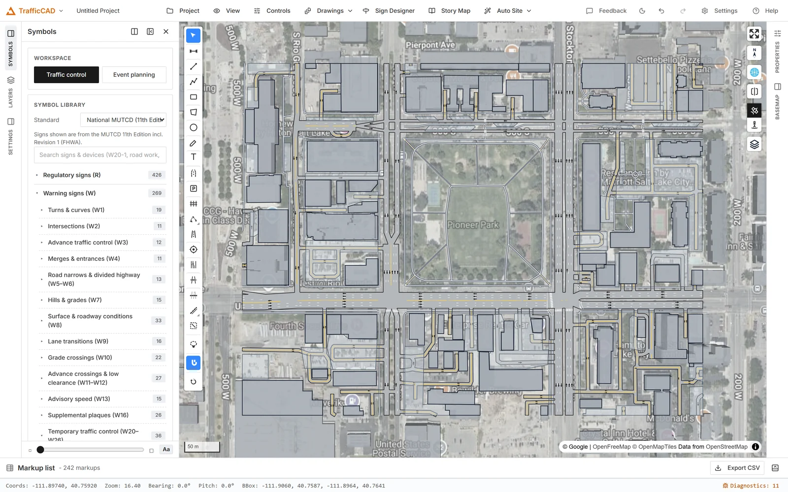
Search any U.S. address and press Auto Site: TrafficCAD vectorizes the live map into editable markup layers over high-resolution aerial imagery. What takes an afternoon of tracing in desktop CAD takes one click here.
One-click vectorize — roads, sidewalks, buildings, and parking arrive as parametric objects, split into per-block segments at every intersection, with real widths and speed limits captured from the data
Design on live aerial imagery from Esri, Google, and USGS NAIP at true scale — and the same imagery rides into your sheet exports
Parametric roads carry width, lanes, speed, and markings — change a lane count and the whole corridor restripes, junction-aware
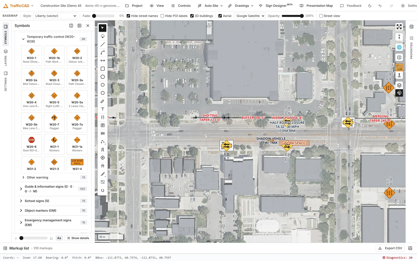
Draw the work area and generate the plan. The TTC engine reads the road, selects the closure strategy, and computes every taper, buffer, and spacing straight from MUTCD Part 6 — then prints the citation next to the number.
10 closure strategies — lane closure, one-lane two-way flagger operation, shoulder work, half-road, full closure and more — selected from road geometry and posted speed
Every number cited — taper length per Table 6B-3, buffer space per Table 6B-2, advance sign spacing per Table 6B-1 — chapter and verse, printed on the plan
Devices placed for you — cone and drum chains, flagger stations, arrow boards, and advance warning signs that automatically slide clear of open intersections
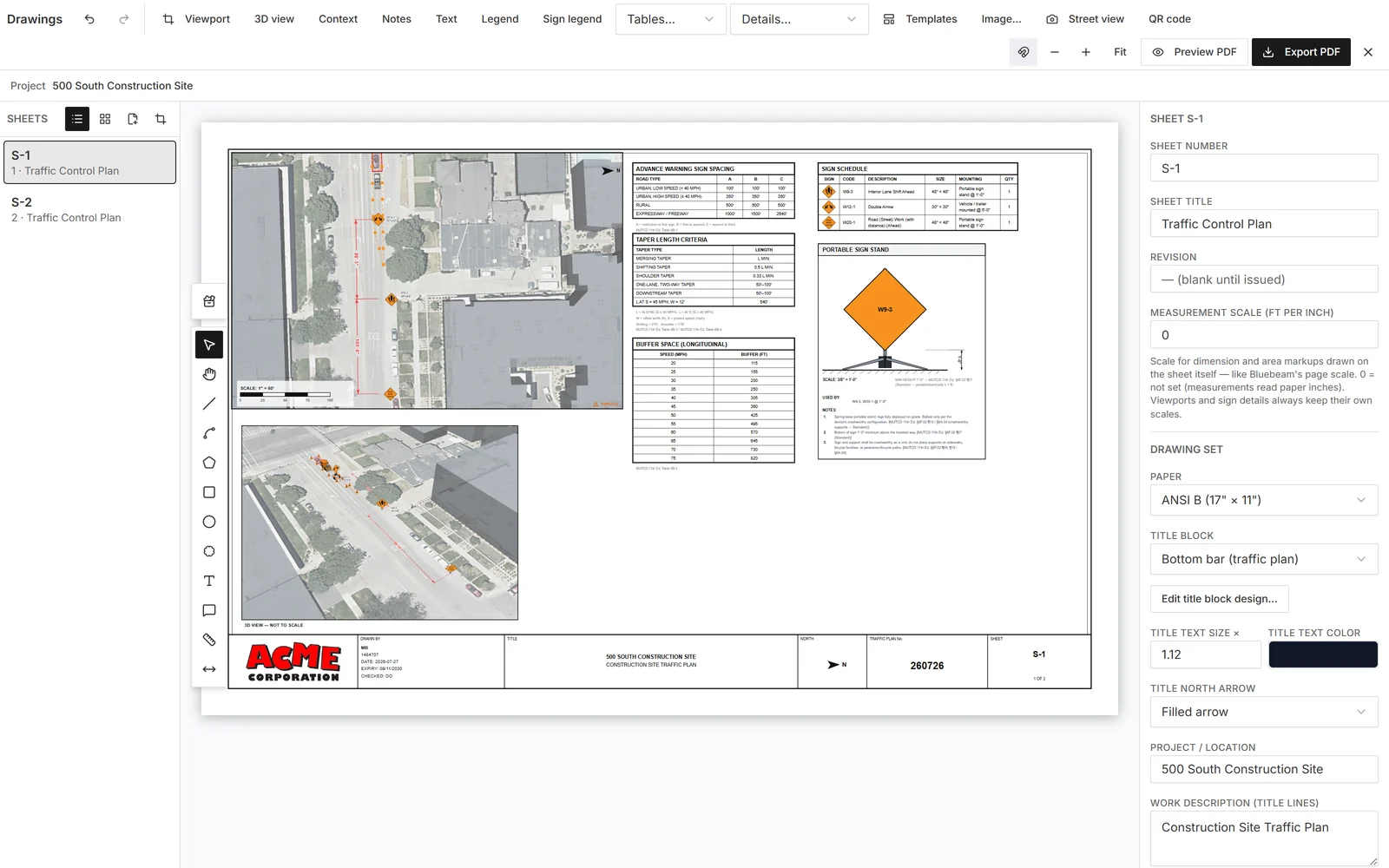
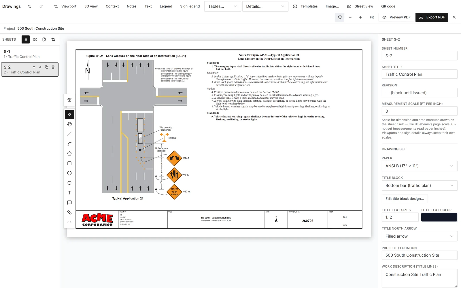
A drawings workspace built for submittal — the stage you edit and the PDF you export are the same renderer, so what you see is exactly what prints.
Multi-sheet drawing sets with title blocks, general notes with citations, scale bars, north arrows, and revision tables — ANSI and ISO sizes, imperial and metric scales
Schedules and quantity takeoffs — sign schedules with mounting details, device counts, markup lists, and CSV exports for estimating and fabrication
Live share links and QR sheets so field crews and reviewers see the current revision — not last week's print
AI plan generation
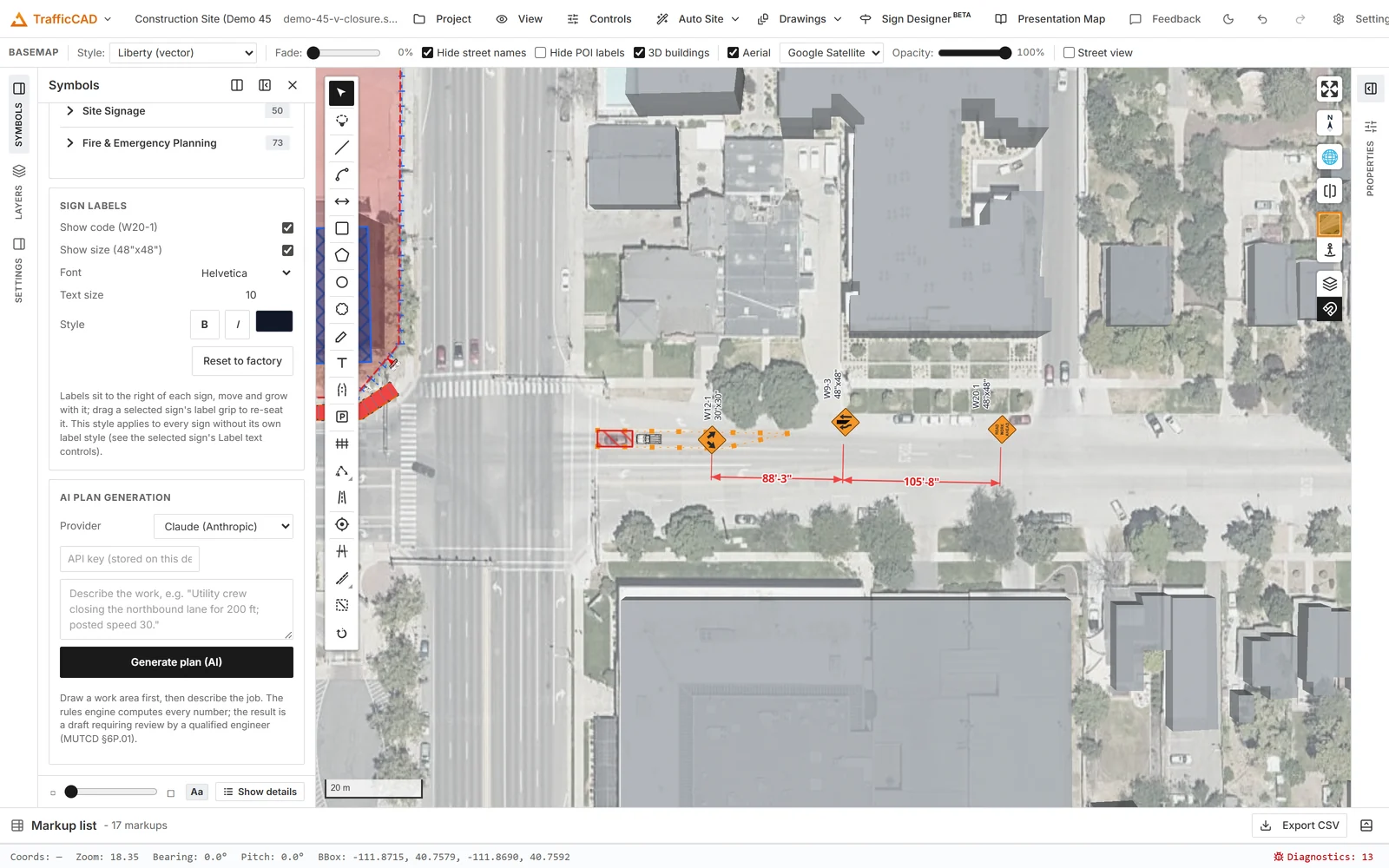
Type “Utility crew closing the eastbound curb lane for 260 ft; posted speed 40.” TrafficCAD drafts the full plan — strategy, tapers, signs, devices, notes. The AI chooses the approach; a deterministic MUTCD engine computes the geometry; a qualified engineer reviews.
Natural-language drafting backed by the same deterministic geometry engine as manual work — no hallucinated dimensions
Cited output — every generated element carries its MUTCD reference, ready for review
Draft-first workflow — generated plans are labeled as drafts requiring review by a qualified engineer (MUTCD §6P.01)
Depth where it counts
Traffic control plan software, a sign design studio, and a pavement-marking engine — the three products competitors license separately — plus the visualization and site tooling none of them have. All included.
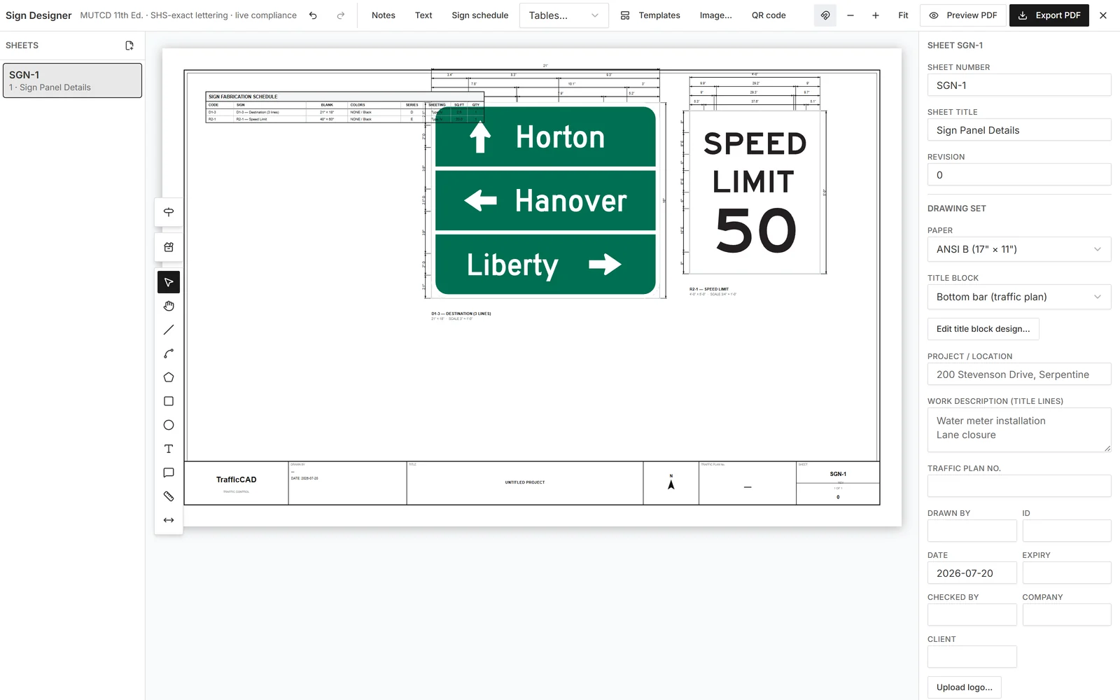
SHS-exact metrics, dynamic panels that re-dimension as you type, shields, arrows, auto dimension chains, and fabrication spec sheets.
Sign design1,055 FHWA signs, work-zone devices, arrow boards, and event symbols — searchable, frequently updated, and every one an editable vector, not a raster stamp.
Symbol libraryA MUTCD Part 3 engine: ground-true line cadences, stop and yield lines, four crosswalk styles, lane-use arrows, TWLTL, and speed-formula turn-bay tapers — 37 cited presets.
MarkingsOpen street-level imagery beside the plan and see your signs rendered in true 3D at mounted height, in the real scene — design review from the driver's seat.
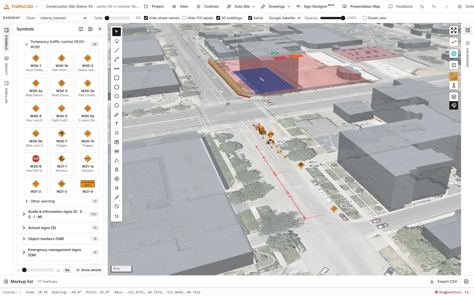
Street viewInstanced 3D meshes of cones, drums, barricades, arrow boards, sign supports, and fences. Pitch the camera through the zone and check what drivers actually see.
VisualizationTurn phased plans into scroll-driven briefings — each chapter flies the map to a saved view with your notes. Present phasing to council without a slide deck.
PresentationPosts, portable skids, Type 3 barricades, flag trees, and vehicle mounts — with per-standard mounting-height rules, including Texas and California nuances.
Sign planningAll seven FHWA Series typefaces built in. Retype any legend on any catalog sign and it re-lays at the exact original geometry — no outlines, no tracing.
TypographyZones with live square footage, routes, walking paths, and a parking-lot generator with guaranteed aisle access — one switch flips the workspace.
EventsEight parametric fence systems — chain-link, barricade, water-filled, silt and more — with gates, bracing, and a per-component bill of materials to CSV.
Site worksTexas TMUTCD 2025 and California MUTCD 2026 ship as full libraries — templates, state sign catalogs, and a standards filter that follows your project.
StandardsShare a live session link the whole team reviews in any browser — no seats to install, no PDF email chains. QR sheets keep field crews on the current revision.
Collaboration
Temporary traffic control
The complete MUTCD Part 6 catalog is live geometry, not a PDF appendix.
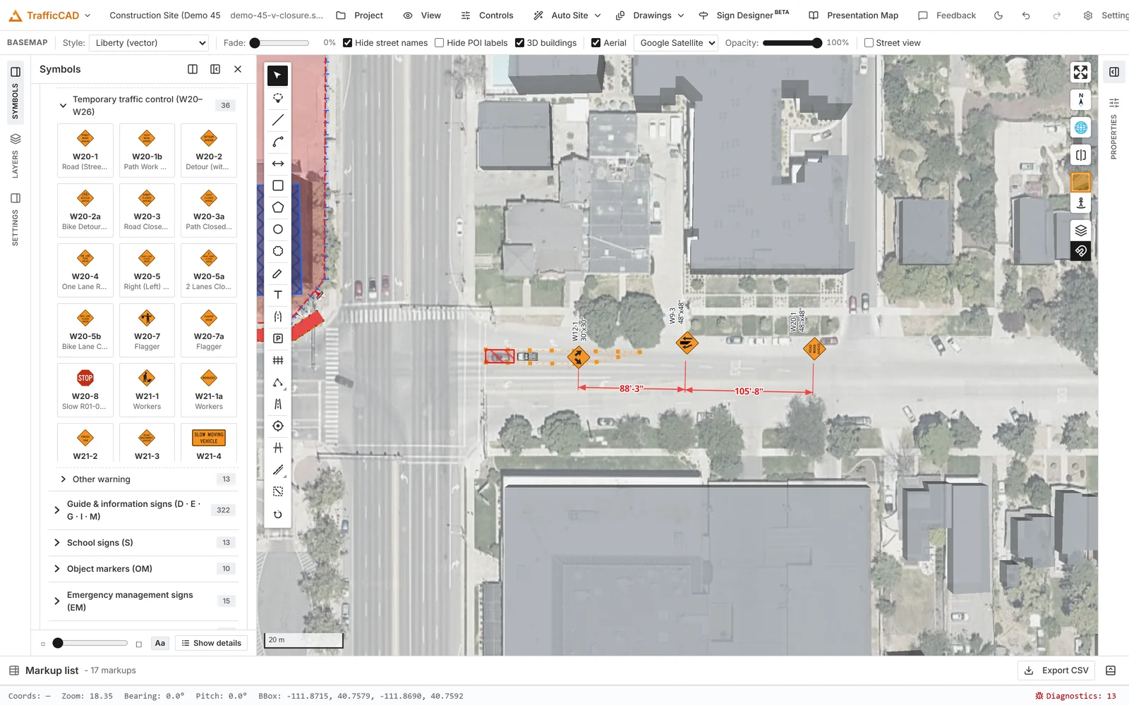
All 54 MUTCD typical applications — plus 506 Part 1–9 figures — as editable vector templates that adapt to your street, your speed, and your standard.
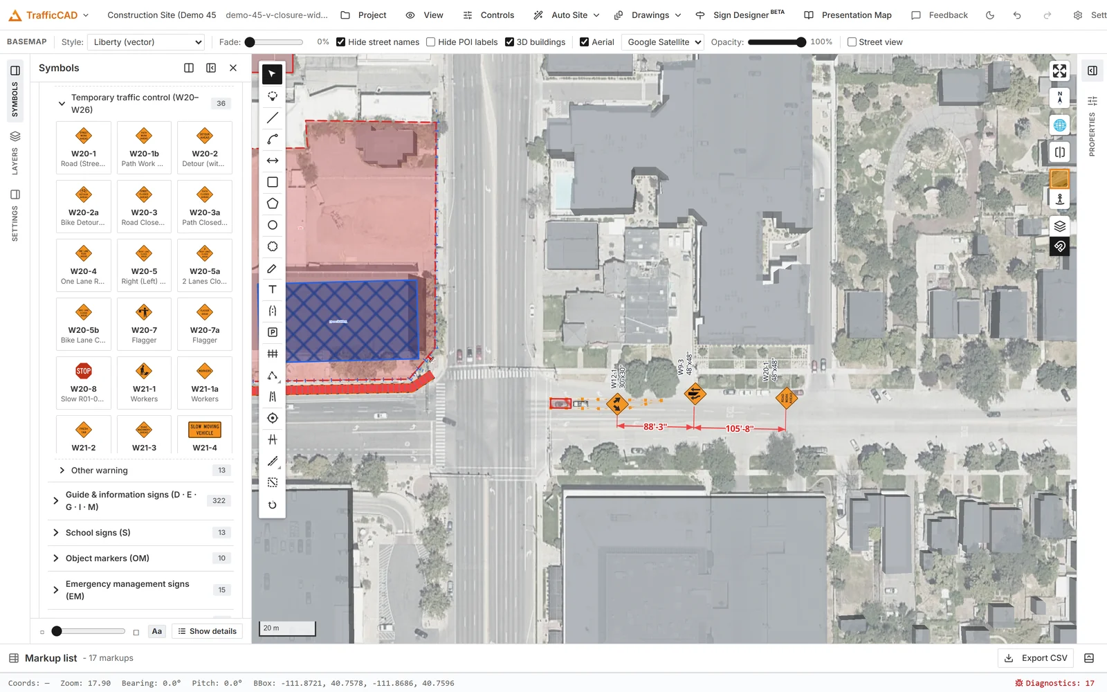
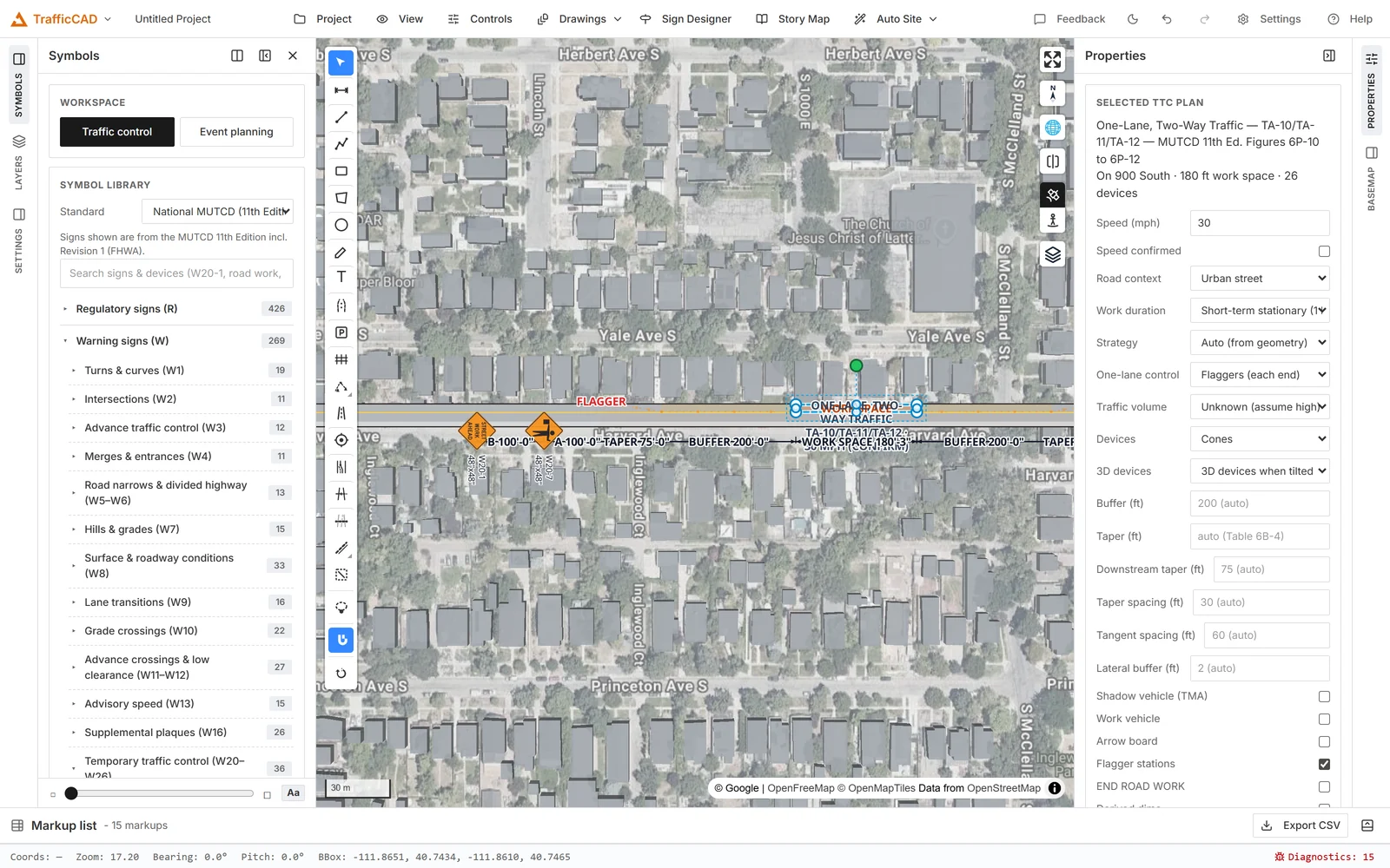
One-lane two-way operation with flagger stations, taper chains, and advance signage — distances computed from posted speed and dimensioned on the plan.
Advance sign spacing per Table 6B-1, tapers per Table 6B-3, buffer space per Table 6B-2 — printed as dimension chains with the reference, ready for the reviewer.
Visualize the impact
2D plan view is for the permit. The other views are for everyone else.
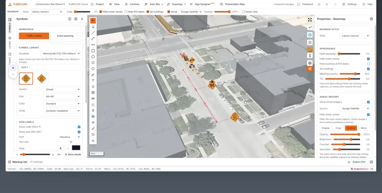
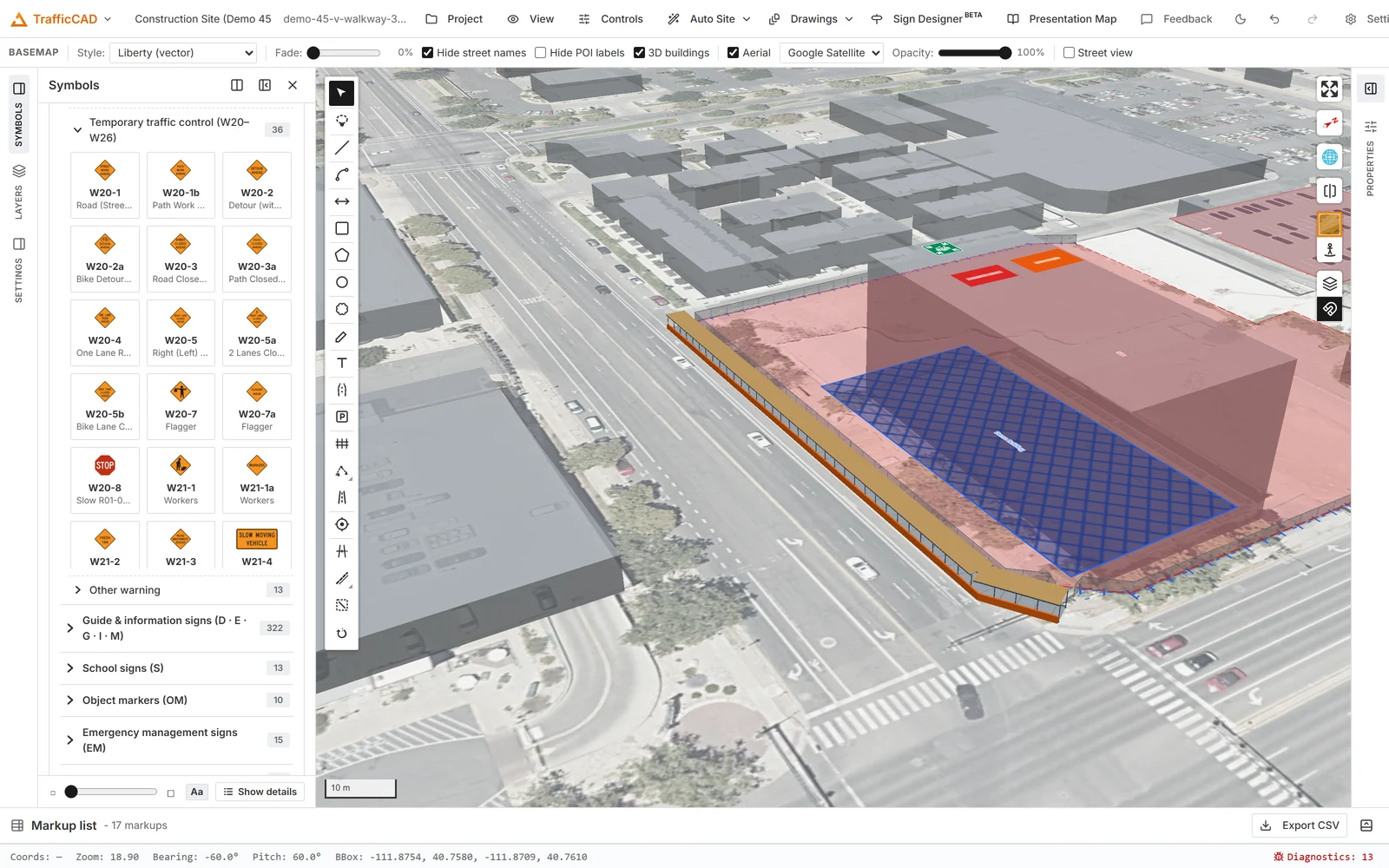
Every cone, drum, barricade, arrow board, and sign support is a real 3D object at real height. Pitch the camera and check sight lines from the driver's seat.
Open Mapillary street-level imagery beside the plan and TrafficCAD renders your planned signs and devices into the photograph in true 3D at mounted height — design review in the real scene.
Chapter by chapter, the map flies from overview to detail with your notes alongside — watch it move — the phased briefing that replaces a slide deck, shared with one link.
Deliverables
The SVG stage and the PDF are the same renderer — no export surprises.
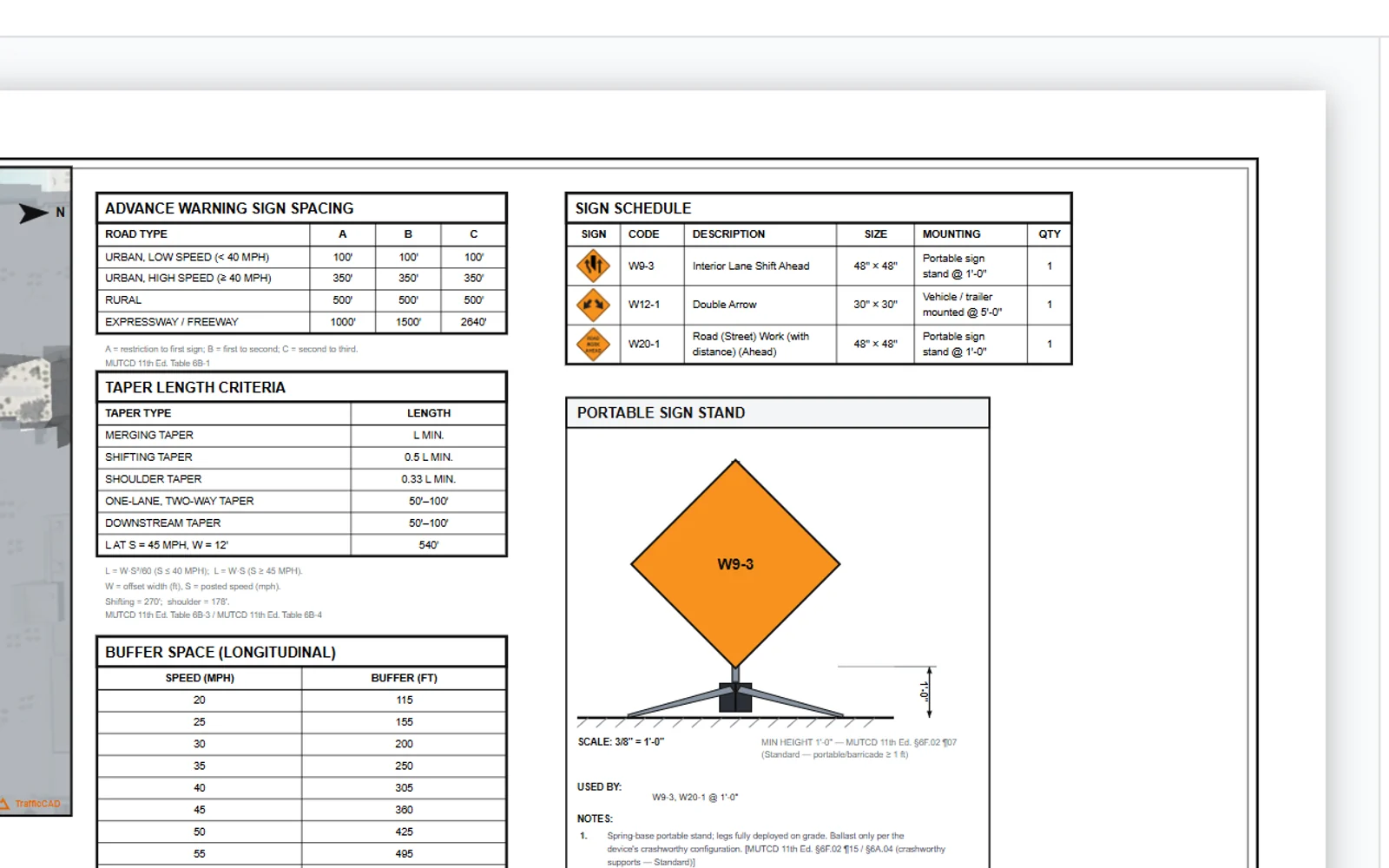
Title blocks, general notes with citations, scale bars, north arrows, and revision tables — ANSI and ISO paper sizes, imperial and metric scales.
Every designed panel exports as a spec sheet with dimension chains, blank size, area, and legibility distance — plus a live fabrication schedule and CSV for the shop.
One click drops a live sign takeoff on the sheet — every placed sign with its MUTCD ID, face size, count, and mounting. It regenerates as the plan changes, and the table is fully customizable: fonts, columns, borders, zebra fills. Device schedules and fencing BOMs export to CSV for the bid.
Insert any of the 506 MUTCD figures — all 54 typical applications included — straight onto the sheet as fully editable vectors, notes page and all. The Texas TMUTCD and California MUTCD libraries ship alongside the national edition.
Every plan exports as a PDF with fully editable markups — open it in Bluebeam and keep working. Signs, dimensions, clouds, and callouts arrive as real annotations, not flattened images.
Watch the whole catalog scroll by — every FHWA sign series plus TTC devices, pavement markings, and event objects, searchable and placeable with MUTCD-published sizes.
Head to head
Other tools help you draw plans. TrafficCAD computes them — tapers, buffers, sign spacing, and device placement calculated from the MUTCD, not traced by hand.
| Capability | TrafficCAD | RapidPlan | Road Manager | GuideSIGN Plus | Traffic Chart |
|---|---|---|---|---|---|
| Full application in any modern browser | separate capped product | Chrome only | — | ||
| No CAD platform required | needs AutoCAD / MicroStation / BricsCAD | ||||
| U.S. MUTCD 11th Edition engine, cited by name | — | — | MUTCD 2023, Plus tier | EU catalogs only | |
| Rule-computed TTC geometry (tapers · buffers · spacing) | — | — | — | — | |
| A citation printed on every computed dimension | — | — | — | — | |
| MUTCD typical applications as live, editable templates | static templates | download templates | smart templates | — | |
| Guide-sign panel designer (SHS metrics, dynamic panels) | — | — | — | ||
| Pavement-marking engine with quantities | manual tools | — | — | ||
| True 3D signs, devices & supports | — | — | 3D view | — | |
| Street-view design review with 3D sign overlay | — | — | — | — | |
| AI plan generation on a deterministic engine | — | — | — | — | |
| Live share links & collaboration | — | link share | |||
| Site & event planning (parking, fencing, BOMs) | — | event TMP pages | — | event maps | |
| Transparent self-serve pricing | from $576/yr | $799/yr desktop · $540/yr web | $580–$760/yr | quote only | €750/yr Pro |
Competitor capabilities and list prices as publicly advertised on vendor websites, July 2026. RapidPlan is a product of Invarion; GuideSIGN of Transoft Solutions; Road Manager of Road Manager; Traffic Chart of Traffic Chart B.V. Verify against current vendor documentation before purchasing decisions.
Who it's for
The engineer who designs it, the agency that approves it, and the crew that builds it — all working from the same live plan.
Traffic engineers & consultants
Municipalities & DOTs
Contractors & event producers
Pricing
No quote calls, no CAD platform underneath, no per-machine licenses. Every plan includes the 1,055-sign catalog, all 506 MUTCD figures, and the Texas & California libraries.
Core
The full CAD workspace — markups, the 1,055-sign catalog, every MUTCD template, state libraries, and PDF sheet sets.
$576 billed annually
See what's includedComplete
Everything in Core, plus real-time collaboration — co-edit with shared cursors, roles, and in-session chat.
$720 billed annually
See what's includedMax
The full engineering platform — advanced road tools, auto-generated cited TTC plans, the Sign Designer, and Road AI.
$900 billed annually
See what's includedQuestions
A traffic control plan (TCP) is a scaled drawing that shows how road users are guided safely past a work zone or event — the closure, tapers, channelizing devices, advance warning signs, and detours. Most agencies require an approved TCP before they issue a permit to occupy a public right-of-way.
TrafficCAD computes plan geometry directly from the MUTCD 11th Edition — taper lengths, buffer space, and sign spacing — and prints the table or section it applied next to each number. Generated plans are drafts requiring review by a qualified engineer, per MUTCD §6P.01.
Texas TMUTCD 2025 and California MUTCD 2026 ship as complete libraries — templates, state sign catalogs, and a standards filter that follows your project — at no extra charge. Additional states are on the roadmap.
No. TrafficCAD is a full CAD-grade editor that runs in any modern browser, or as a desktop app. There is no AutoCAD, MicroStation, or BricsCAD dependency — and nothing to install.
Minutes, not hours. Search the address, draw the work area, and generate: the TTC engine selects the closure strategy and computes every distance from the posted speed and road geometry. Export the permit-ready PDF once your review is done.
TrafficCAD runs $576 to $900 per year per user depending on tier, self-serve with every standard included. For comparison: RapidPlan desktop lists at $799/yr plus $540/yr for its web product, Road Manager at roughly $580–$760/yr, and GuideSIGN is quote-only — and needs a CAD platform underneath.
Yes. A GuideSIGN-class sign designer with SHS-exact lettering, dimension chains, and fabrication spec sheets — plus a MUTCD Part 3 pavement-marking engine with cited presets and quantity takeoffs. One workspace, no separate modules to buy.
Those tools help you draw plans; TrafficCAD computes them. It covers their advertised workflows — map-based TCP drawing, sign design, pavement markings, collaboration — then adds what none of them advertise: a cited MUTCD 11th Edition geometry engine, AI drafting, true 3D, street-view design review, and presentation maps.
Documentation & support
A complete user guide and step-by-step tutorials — written against the real interface, with the MUTCD citations your reviewers expect.
Run TrafficCAD, find your site, place your first signs, and save a project — the ten-minute on-ramp.
Start hereEvery feature, documented: markup tools, sign design, TTC plans, markings, fencing, events, sheets, and sharing — with exact controls and citations.
ReferenceSeven end-to-end walkthroughs — from your first traffic plan to generated TTC plans, sign design, fencing with BOMs, and publishing sheet sets.
Hands-onFeature drops, standards updates — MUTCD, TMUTCD, California MUTCD — and engineering notes. No spam, unsubscribe anytime.